Regional
Regional map of Nicaragua.
Nicaragua:
Total land area of 130,370 square km.
Land area of 119,990 square km.
Water area of 10,380 square km.
Slightly smaller than New York.
Borders Honduras and Costa Rica.
Total distance of all land boundaries is 1,231 km.
Total distance of Coastline is 910 km.
Climate consists of tropical in lowlands and cooler in the highlands.
The terrain is extensive Atlantic coastal plains rising to central interior mountains and narrow Pacific coastal plain interrupted by volcanoes.
It's lowest point is the Pacific Ocean at 0 m.
It's highest point is at 2,438 m.
Terrain
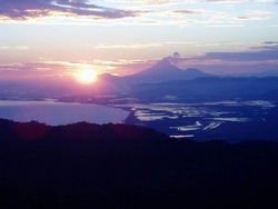
A visual encapsulating Nicaragua's varying physical landscape features, such as its' mountains and coastal plains.
Borders Honduras and Costa Rica.
Total distance of all land boundaries is 1,231 km.
Total distance of Coastline is 910 km.
Climate consists of tropical in lowlands and cooler in the highlands.
Total distance of all land boundaries is 1,231 km.
Total distance of Coastline is 910 km.
Climate consists of tropical in lowlands and cooler in the highlands.
Country Specific
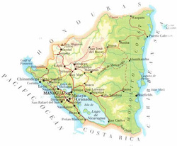
A country specific map illustrating a broad look at Nicaragua's physical features.
The terrain is extensive Atlantic coastal plains rising to central interior mountains and narrow Pacific coastal plain interrupted by volcanoes.
It's lowest point is the Pacific Ocean at 0 m.
It's highest point is at 2,438 m.
It's lowest point is the Pacific Ocean at 0 m.
It's highest point is at 2,438 m.
